Lois Bolin, PhD, Old Naples Historian
The Making of the Trail
by Lois Bolin, Ph.D., Old Naples Historian
by Keith Basik
- Staking “Rod men” would machete a path and place center stakes every 100 feet.
- Clearing Clearing crews would cut down trees, sometimes standing in waist-deep water, and move them with oxen.
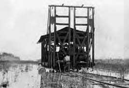
- Blasting Crews would then lay industrial rail for drilling machines. Three holes were drilled simultaneously, approximately 12 feet deep. The holes were marked as the machine moved 6 feet to drill the next holes. Blasting crews would muck holes and place charges of 10-40 sticks of dynamite per hole. After setting approximately 500- 600 pounds of dynamite, the crew would blast.
- Dredging Once the rock was blasted, three Bay City Dredges would work in tandem, roughly 400 feet apart from each other, to dredge the canal on the north side of the road. The canal was approximately 20’ wide and 15’ deep. The canal provided drainage to keep the road from flooding, as well as material to be used for the roadbed. It took one month to dredge 1.5 miles.
- Leveling The “Bay City Skimmer Scoop” would level the piles of fill, doing the work of at least 50 men. At this point, wheeled vehicles could pass.
- Grading/Fine Grading Grading crew would do the finished grading and topping. No rocks larger than two inches in diameter could be within 6 inches of the surface. Finally, they would smooth the surface and apply asphalt.
Reference
The above outline was compiled based an article that first appeared in the Collier County Heritage Magazine, a publication of the Collier County Historical Society. The entire article was written by Colonel Frank F. Tenney, Jr. (USAF Ret.). The article also appeared in “The Tamiami Trail,” a collection of stories by Maria Stones.
road construction bonding
Below reflects the bonding expenditures for the construction of Tamiami Trail. Note that the figures only pertaining to cost between east Miami and north Ft. Myers (approx.). The portion of the Trail from north Ft. Myers to Tampa was built prior to 1916.
Collier (76 Miles): $350,000
$350,000
$200,000
$200,000
$1,100,000
Charlotte to Ft. Myers: $74,000
Caloosahatchee Bridge: $110,000
Ft. Myers to Marco: $175,000
Marco Junction to Dade: $125,000
Ft. Myers to Bonita Springs: $600,000
(rebuilding road) $1,084,000
Dade County (42 Miles): $250,000
$50,000
$125,000
$160,000
$585,000
Monroe County: $210,000
Chevelier Corporation: $333,000
State Road Department: $3,547,000
Additional Expenditures (est.): $1,141,000
TOTAL : $8,000,000
Segment Breakdowns (approx. miles):
- Total Mileage of Tamiami Trail: 274 Tampa to Miami
- Miami to Dade County Line: 42 Miles
- Naples to Dade County Line: 76 Miles
- Ft. Myers to Naples: 45 Miles
Reference
1. “History of the Tamiami Trail,” Published by Authority of the Tamiami Trail Commissioners and
the County Commissioners of Dade County, Florida, Miami 1928.
Trail Timeline
1914
Captain James F. Jaudon
(regarded as the “Father of the
Trail”) and Indian guide Jack
Tigertail survey the Everglades
for a possible route.
1915
(April) An informal meeting between J. F. Jaudon of Miami and Francis Perry, Ft. Myers Chamber of Commerce, in Tallahassee. Upon
returning to their respective counties, each begins setting the wheels in motion.
(June 10) Central Florida Highway Association was created for numerous road projects in the State of Florida. The “Tamiami Trail” project
was formally introduced –prior to that time, and for a period of time afterwards, it was referred to as the Miami-Marco Road. Other names included: Miami to Marco Highway and Atlantic to Gulf Boulevard.
The name Tamiami Trail (original coinage was “Tamiam”) was based upon the road extending from Tampa to Miami. President of the Tampa Board of Trade, D.C. Gillett, is credited with coining the name (June 3, 1915 in Miami).
(August) Preliminary Survey conducted. Miami-Marco Road and Canal Commission established. Initial bonding requirements set forth.
(October 19) Lee County obtains initial bond for road construction.
1916
(January) Dade County obtains initial bond.
(February) Permanent survey completed. No bidders on project— too difficult.
(May) New specifications established—J.B. McCrary Co. (Dade County) awarded contract.
(September) Work begins on trail.
Lee County (Collier not formed yet) is responsible for extending the road (121 miles–of which 76 miles will be within Collier) to the Dade County line. Dade County is responsible for only 42 miles.
Jaudon organizes the Chevelier Corporation, which purchased 207,360 acres (The Hopkins Tract) lying mostly in Monroe County, a fraction of it being in Dade County.
1917
(February) Surveying party missing in the Everglades for several weeks.
1919
It becomes apparent that Lee County will not be able to complete link for financial reasons. Jaudon, now President of the Chevelier Corporation, offers to continue Tamiami Trail from Dade County line westward to help link both sides, changing the original route that was to the North.
Commissioners of all counties agree to the route change. This road would later be named Loop Road.
1921
Chevelier Corporation begins construction of new route through their holdings. Construction comes to nearly a standstill in southeastern Lee County (i.e., eastern Collier County) due to lack of funding.
The initial funding was based upon population of a community. Naples’ population is roughly 1,200 people.
1923
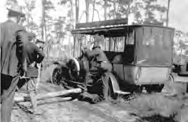
Ten Model Ts, one Elcar and twenty men (“the Trail Blazers”) make a grueling crossing of the Everglades to help restart the project. The trip takes 23 days (instead of the 3 days projected) and garners national attention.
Barron Collier pledges to finish the Trail to the Dade County line. Tommie Barfield pushes hard to get state support. The state agrees to make Collier its own county, separate from Ft. Myers. Work progresses.
Chevelier Corporation completes 19 miles of new route, expending over $300,000 in two years, to the northern portion of their property
along the Collier and Monroe County boundary.
Barron Collier, then, asks that the original route (continuing through Collier County) be used and not to accept the route just completed by the Chevelier Corporation. This recommendation infuriates Jaudon. The controversy continues until January 1926.
Land boom causes high worker turnover (as high as 50% per month).
1926
(August) After spending $1 milli n and fighting labor issues, there remains 31 miles of the most difficult terrain left to get to the Dade County line. Newly elected Governor Martin pledges to complete the Trail.
The state secures “South Loop” Road and Tamiami Trail. Barron Collier and the state move forward with construction. D. Graham Copeland (of Alexander, Ramsay and Kerr engineering) becomes chief engineer for the project. The same firm is simultaneously working on the Immokalee to
Everglades road/railway.
(September 18) The Great (Miami) Hurricane hits and causes a tidal wave that destroys part of the Trail. In the Miami area, Red Cross estimates 347 fatalities and $140 Billion in damages (in 2006 dollars). Florida’s land boom starts to falter. Workers are easy to obtain.
1928
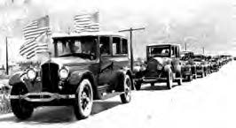
On April 26 the Trail is complete. A convoy of 500 cars departs Ft. Myers for the opening ceremony held at Everglades City.